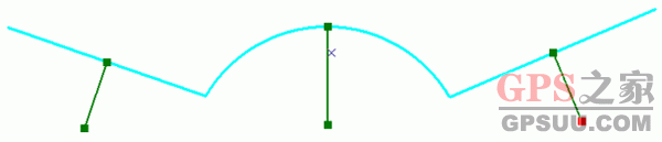
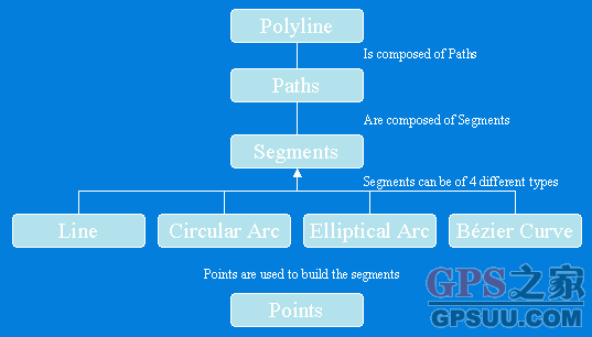
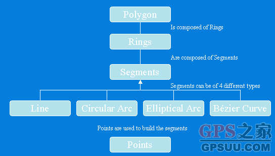
ArcEngine Geometry库定义了基本几何图形的矢量表达形式,顶级的几何图形有Points、Multipoints、Polylines、Polygons、Multipatches,Geodatabase和绘图系统使用这些几何图形来定义其他各种形状的特征和图形,提供了编辑图形的操作方法和地图符号系统符号化特征数据的途径。  public IPolyline TestGeometryEnvironment() public IPolyline TestGeometryEnvironment()   { { ISpatialReferenceFactory spatialReferenceFactory = new SpatialReferenceEnvironmentClass(); //Create a projected coordinate system and define its domain, resolution, and x,y tolerance. ISpatialReferenceResolution spatialReferenceResolution = spatialReferenceFactory.CreateProjectedCoordinateSystem((int)esriSRProjCSType.esriSRProjCS_NAD1983UTM_11N) as ISpatialReferenceResolution; spatialReferenceResolution.ConstructFromHorizon(); ISpatialReferenceTolerance spatialReferenceTolerance = spatialReferenceResolution as ISpatialReferenceTolerance; spatialReferenceTolerance.SetDefaultXYTolerance(); ISpatialReference spatialReference = spatialReferenceResolution as ISpatialReference; //Create an array of WKSPoint structures starting in the middle of the x,y domain of the //projected coordinate system. double xMin; double xMax; double yMin; double yMax; spatialReference.GetDomain(out xMin, out xMax, out yMin, out yMax); double xFactor = (xMin + xMax) * 0.5; double yFactor = (yMin + yMax) * 0.5; WKSPoint[] wksPoints = new WKSPoint[10]; for (int i = 0; i < wksPoints.Length; i++) ISpatialReferenceFactory spatialReferenceFactory = new SpatialReferenceEnvironmentClass(); //Create a projected coordinate system and define its domain, resolution, and x,y tolerance. ISpatialReferenceResolution spatialReferenceResolution = spatialReferenceFactory.CreateProjectedCoordinateSystem((int)esriSRProjCSType.esriSRProjCS_NAD1983UTM_11N) as ISpatialReferenceResolution; spatialReferenceResolution.ConstructFromHorizon(); ISpatialReferenceTolerance spatialReferenceTolerance = spatialReferenceResolution as ISpatialReferenceTolerance; spatialReferenceTolerance.SetDefaultXYTolerance(); ISpatialReference spatialReference = spatialReferenceResolution as ISpatialReference; //Create an array of WKSPoint structures starting in the middle of the x,y domain of the //projected coordinate system. double xMin; double xMax; double yMin; double yMax; spatialReference.GetDomain(out xMin, out xMax, out yMin, out yMax); double xFactor = (xMin + xMax) * 0.5; double yFactor = (yMin + yMax) * 0.5; WKSPoint[] wksPoints = new WKSPoint[10]; for (int i = 0; i < wksPoints.Length; i++)  { wksPoints[i].X = xFactor + i; wksPoints[i].Y = yFactor + i; { wksPoints[i].X = xFactor + i; wksPoints[i].Y = yFactor + i; } IPointCollection4 pointCollection = new PolylineClass(); IGeometryBridge2 geometryBridge = new GeometryEnvironmentClass(); geometryBridge.AddWKSPoints(pointCollection, ref wksPoints); IPolyline polyline = pointCollection as IPolyline; polyline.SpatialReference = spatialReference; return polyline; } IPointCollection4 pointCollection = new PolylineClass(); IGeometryBridge2 geometryBridge = new GeometryEnvironmentClass(); geometryBridge.AddWKSPoints(pointCollection, ref wksPoints); IPolyline polyline = pointCollection as IPolyline; polyline.SpatialReference = spatialReference; return polyline; } }
private IPolygon GeometryBag_Example(IFeatureClass featureClass){ //Check input objects. if (featureClass == null) { return null; } IGeoDataset geoDataset = featureClass as IGeoDataset; ISpatialFilter queryFilter = new SpatialFilterClass(); //Set the properties of the spatial filter here. IGeometry geometryBag = new GeometryBagClass(); //Define the spatial reference of the bag before adding geometries to it. geometryBag.SpatialReference = geoDataset.SpatialReference; //Use a nonrecycling cursor so each returned geometry is a separate object. IFeatureCursor featureCursor = featureClass.Search(queryFilter, false); IGeometryCollection geometryCollection = geometryBag as IGeometryCollection; IFeature currentFeature = featureCursor.NextFeature(); while (currentFeature != null) { //Add a reference to this feature's geometry into the bag. //You don't specify the before or after geometry (missing), //so the currentFeature.Shape IGeometry is added to the end of the geometryCollection. object missing = Type.Missing; geometryCollection.AddGeometry(currentFeature.Shape, ref missing, ref missing); currentFeature = featureCursor.NextFeature(); } // Create the polygon that will be the union of the features returned from the search cursor. // The spatial reference of this feature does not need to be set ahead of time. The // ConstructUnion method defines the constructed polygon's spatial reference to be the same as // the input geometry bag. ITopologicalOperator unionedPolygon = new PolygonClass(); unionedPolygon.ConstructUnion(geometryBag as IEnumGeometry); return unionedPolygon as IPolygon;}
public IPolyline ConstructMultiPartPolyline(IPolyline inputPolyline){ IGeometry outGeometry = new PolylineClass(); //Always associate new, top-level geometries with an appropriate spatial reference. outGeometry.SpatialReference = inputPolyline.SpatialReference; IGeometryCollection geometryCollection = outGeometry as IGeometryCollection; ISegmentCollection segmentCollection = inputPolyline as ISegmentCollection; //Iterate over existing polyline segments using a segment enumerator. IEnumSegment segments = segmentCollection.EnumSegments; ISegment currentSegment; int partIndex = 0;; int segmentIndex = 0;; segments.Next(out currentSegment,ref partIndex, ref segmentIndex); while(currentSegment != null) { ILine normal = new LineClass(); //Geometry methods with _Query_ in their name expect to modify existing geometries. //In this case, the QueryNormal method modifies an existing line //segment (normal) to be the normal vector to //currentSegment at the specified location along currentSegment. currentSegment.QueryNormal(esriSegmentExtension.esriNoExtension, 0.5, true, currentSegment.Length / 3, normal); //Since each normal vector is not connected to others, create a new path for each one. ISegmentCollection newPath = new PathClass(); object missing = Type.Missing; newPath.AddSegment(normal as ISegment, ref missing, ref missing); //The spatial reference associated with geometryCollection will be assigned to all incoming paths and segments. geometryCollection.AddGeometry(newPath as IGeometry, ref missing, ref missing); segments.Next(out currentSegment,ref partIndex, ref segmentIndex); } //The geometryCollection now contains the new, multipart polyline. return geometryCollection as IPolyline;}
Polygons public IMultiPatch CreateMultipatch(){ //Prepare the geometry material list. IGeometryMaterial texture = new GeometryMaterialClass(); texture.TextureImage = C:TempMyImage.bmp; IGeometryMaterialList materialList = new GeometryMaterialListClass(); materialList.AddMaterial(texture); //Create the multipatch. IGeneralMultiPatchCreator multiPatchCreator = new GeneralMultiPatchCreatorClass(); multiPatchCreator.Init(4, 1, false, false, false, 4, materialList); //Set up part. //Could also use a Ring or a TriangleFan. multiPatchCreator.SetPatchType(0, esriPatchType.esriPatchTypeTriangleStrip); multiPatchCreator.SetMaterialIndex(0, 0); multiPatchCreator.SetPatchPointIndex(0, 0); multiPatchCreator.SetPatchTexturePointIndex(0, 0); //Set real-world points. WKSPointZ upperLeft = new WKSPointZ(); WKSPointZ lowerLeft = new WKSPointZ(); WKSPointZ upperRight = new WKSPointZ(); WKSPointZ lowerRight = new WKSPointZ(); upperLeft.X = 0; upperLeft.Y = 0; upperLeft.Z = 0; upperRight.X = 300; upperRight.Y = 0; upperRight.Z = 0; lowerLeft.X = 0; lowerLeft.Y = 0; lowerLeft.Z = -100; lowerRight.X = 300; lowerRight.Y = 1; lowerRight.Z = -100; multiPatchCreator.SetWKSPointZ(0, ref upperRight); multiPatchCreator.SetWKSPointZ(1, ref lowerRight); multiPatchCreator.SetWKSPointZ(2, ref upperLeft); multiPatchCreator.SetWKSPointZ(3, ref lowerLeft); //Set texture points. //Set the texture coordinates for a panel. WKSPoint textureUpperLeft = new WKSPoint(); WKSPoint textureLowerLeft = new WKSPoint(); WKSPoint textureUpperRight = new WKSPoint(); WKSPoint textureLowerRight = new WKSPoint(); textureUpperLeft.X = 0; textureUpperLeft.Y = 0; textureUpperRight.X = 1; textureUpperRight.Y = 0; textureLowerLeft.X = 0; textureLowerLeft.Y = 1; textureLowerRight.X = 1; textureLowerRight.Y = 1; multiPatchCreator.SetTextureWKSPoint(0, ref textureUpperRight); multiPatchCreator.SetTextureWKSPoint(1, ref textureLowerRight); multiPatchCreator.SetTextureWKSPoint(2, ref textureUpperLeft); multiPatchCreator.SetTextureWKSPoint(3, ref textureLowerLeft); IMultiPatch multiPatch = multiPatchCreator.CreateMultiPatch() as IMultiPatch; return multiPatch;} |
GPS软件应用 Geometry 对象浅析
时间:2008-01-18 10:48来源:GPS之家 作者:网络
ArcEngine Geometry库定义了基本几何图形的矢量表达形式,顶级的几何图形有Points、Multipoints、Polylines、Polygons、Multipatches,Geodatabase和绘图系统使用这些几何图形来定义其他各种形状的特征和图形,提供了编辑图形的操作方法和地图符号系统符号化
[ GPSUU整理发布,版权归原作者所有。]
顶一下
(1)
50%
踩一下
(1)
50%
------分隔线----------------------------
- 推荐内容
-
- GPS软件应用 MapInfo格式到ArcInfo格式的转换
MapInfo中的地图可以有两种格式:Tab格式(表格式)、Mif格式(交换格式)。 ArcInfo...
- 用MapX快速开发
一、加载地图数据 1、 TAB的数据分为两种数据:地图数据(Layers)、属性数据(Datase...
- GPS软件应用 MapInfo Professional 8.0
MapInfo Professional 8.0 -- 世界领先的桌面地图软件及GIS分析系统 MapInfo Professi...
- GPS软件应用 用VC开发Mapinfo程序
开发环境:VC + MapInfo Professional 代码: 所用软件:Mapinfo,MapBasic,VC++6.0 先...
- GPS学堂 shapefile 和 MapGIS 文件格式之间的
假如在ArcGIS中存在一个Coverage图层cover,只包含线的信息没有点,我们用 ArcTools先...
- GPS学堂 CAD转MAPINFO格式
一、 在CAD里画好的图,左下角坐标与右上角坐标必须控制在(X1=0,Y1=0;X2=5000,Y2=...
- GPS软件应用 MapInfo格式到ArcInfo格式的转换
- 图文新闻

GPS软件应用 Geometry